
Introduction
Creating effective routing protocols is a significant difficulty in the quickly changing field of Mobile Ad Hoc Networks (MANETs), because node mobility causes network architecture to alter regularly. Because they use flooding processes to find routes, traditional routing protocols like AODV and DSR frequently have significant control packet overhead. This becomes resource-intensive and wasteful, particularly in networks that are big or very dynamic. Location-Aided Routing (LAR) was developed to solve this problem. LAR restricts the region in which route discovery packets are transmitted by using geographic location data, usually acquired through the Global Positioning System (GPS). In doing so, it enhances the effectiveness of route discovery procedures and drastically lowers routing overhead. This blog post goes into great detail about LAR, including its advantages, practical uses, and guiding principles. Gaining knowledge of LAR can help network professionals, researchers, and students alike better grasp how location awareness can improve communication in mobile networks.
What is LAR?
A location-based routing system called Location-Aided Routing (LAR) was created specifically for Mobile Ad Hoc Networks (MANETs). By limiting the extent of route request (RREQ) flooding, it makes use of the actual locations of mobile nodes to improve route finding efficiency. Young-Bae Ko and Nitin H. Vaidya proposed LAR in an attempt to reduce control overhead and maximize bandwidth utilization. LAR defines a restricted “search area” where the route request should be disseminated according on the destination node’s geographic location rather than broadcasting it throughout the network. Key Concepts in LAR are,
- Expected Zone: A region where the destination node is likely to be located, based on its last known location and mobility patterns.
- Request Zone: A defined area within which the route request packets are forwarded. It typically contains the Expected Zone and is used to limit unnecessary message propagation.
Two Main LAR Schemes:
- LAR Scheme 1 (Request Zone-Based): The source defines a rectangular request zone that includes the expected location of the destination. Only nodes within this zone forward the route request.
- LAR Scheme 2 (Distance-Based Forwarding): Each node decides whether to forward a route request based on its distance to the destination. Nodes closer to the destination have a higher probability of forwarding the packet.
To avoid making pointless route requests in places where the destination is unlikely to be discovered in order to reduce routing overhead and save bandwidth. Mobile networks, particularly those with frequent topology changes, like military, disaster recovery, and vehicle networks, perform better thanks to LAR’s clever use of position data.
How Location-Aided Routing Works ?
By employing location data to restrict the spread of route request (RREQ) packets, Location-Aided Routing (LAR) improves on conventional route discovery while lowering overhead in Mobile Ad Hoc Networks (MANETs). Here is a detailed breakdown of LAR’s operation, emphasizing its two primary schemes:
Step 1: Source Node Gets Location Information
- The source node wants to send data to a destination node. It must know the last known location and movement characteristics (e.g., speed, direction) of the destination. This information is typically obtained through GPS or periodically exchanged location beacons.
Step 2: Define the Expected Zone
- Based on the destination’s last known location and the time elapsed, the source estimates the Expected Zone. The Expected Zone is a circular area where the destination is most likely to be found. Its radius is usually determined by multiplying the destination’s speed by the elapsed time since the last location update.
Step 3: Define the Request Zone
- A Request Zone is then defined to enclose both the source node and the Expected Zone. The shape is typically a rectangle (in Scheme 1) or an area defined by distance (in Scheme 2). Only nodes within this zone are allowed to forward the RREQ.
Step 4: Broadcasting Within the Request Zone
- The source node initiates route discovery by broadcasting the RREQ.
- Nodes inside the Request Zone:
- Check if they are closer to the destination or part of the route path.
- Forward the request to their neighbors.
- Nodes outside the zone:
- Discard the RREQ.
- This drastically reduces unnecessary network traffic.
Step 5: Route Reply and Data Transmission
- If the RREQ reaches the destination (or a node with a route to it), a Route Reply (RREP) is sent back to the source. The data transmission begins once the route is established.
| Feature | LAR Scheme 1 | LAR Scheme 2 |
| Forwarding Decision | Based on whether node is inside Request Zone | Based on node’s distance to destination |
| Broadcast Scope | Limited to defined rectangle | More dynamic, based on proximity |
| Overhead Reduction | High | Moderate to high |
By intelligently restricting the area in which routing messages are propagated, LAR conserves bandwidth, reduces collisions, and improves efficiency in highly dynamic networks.
Example of Location-Aided Routing Protocol
Let’s explore how LAR (Location-Aided Routing) works through a simple example using LAR Scheme 1, which is based on the Request Zone.
Scenario,
- Suppose Node S (Source) wants to send data to Node D (Destination).
- The last known location of Node D was at coordinates (100, 100) five seconds ago.
- Node D moves with a maximum speed of 10 m/s.
- Therefore, the Expected Zone is a circle with a radius of 50 meters centered at (100, 100).
Request Zone
- To ensure route discovery is efficient, Node S defines a Request Zone: A rectangle that includes both Node S and the Expected Zone. Only nodes within this rectangle are allowed to forward the Route Request (RREQ) packets.
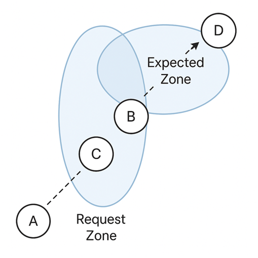
Consider a scenario in a Mobile Ad Hoc Network (MANET) where Node S (Source) wants to send data to Node D (Destination). The source node is aware of the destination’s last known position, which was at coordinates (100, 100), and it also knows that the destination node moves at a maximum speed of 10 meters per second. Assuming that this position information is 5 seconds old, the source estimates that the destination could now be anywhere within a circle of radius 50 meters (10 m/s × 5 s) centered at the last known position. This circular area is called the Expected Zone. To control the flooding of route request (RREQ) packets, the source node defines a larger rectangular area, known as the Request Zone, which includes both the source node and the Expected Zone. The Request Zone acts as a boundary for route discovery, meaning only nodes within this rectangle are allowed to forward the RREQ packets. Nodes outside this zone simply drop the RREQs to prevent unnecessary propagation.
For instance, if Node A lies within the Request Zone, it will forward the RREQ, whereas Node X, located outside the Request Zone, will discard it. This targeted broadcasting reduces network congestion, conserves bandwidth, and minimizes routing overhead. Once the RREQ reaches the destination node D or a node that has a route to D, a Route Reply (RREP) is sent back to the source, completing the route discovery. The data transmission then begins along this established path. This approach showcases how LAR intelligently leverages geographic information to make routing more efficient and scalable in dynamic wireless environments.
Key Features of Location-Aided Routing
Location-Aided Routing (LAR) brings several innovative features that make it well-suited for dynamic and mobile wireless networks. Below are the key features that define how LAR operates and what sets it apart from traditional routing protocols:
- Location Awareness: LAR utilizes geographic position information (typically from GPS) to guide the route discovery process. This allows the protocol to intelligently narrow the search area for a route.
- Controlled Flooding Using Zones: Instead of blind flooding, LAR limits the propagation of Route Request (RREQ) packets to a predefined Request Zone. This significantly reduces network overhead and collisions.
- Two Routing Schemes:
Scheme 1 (Request Zone Based): Only nodes inside the rectangular request zone can forward route requests.
Scheme 2 (Distance Based): Nodes decide to forward requests based on their distance from the destination.
- Scalability in High Mobility: LAR is highly effective in large-scale networks with high node mobility. By using expected locations, it avoids unnecessary discovery in irrelevant parts of the network.
- Compatibility with MANETs and VANETs: Designed for Mobile Ad Hoc Networks, but also well-suited for Vehicular Ad Hoc Networks (VANETs) where node movement is predictable and frequent.
- Reduction in Control Packet Overhead: Limits the number of control messages compared to protocols like AODV or DSR, leading to lower bandwidth consumption.
- Predictive Zone Modeling: Incorporates mobility prediction (speed × time) to define an Expected Zone, enhancing route accuracy.
- Flexible Implementation: Can be integrated into existing routing frameworks with minimal changes. Does not require all nodes to be location-aware—only the source and destination.
Together, these features make LAR a smart, adaptive, and bandwidth-efficient routing protocol, especially in scenarios where node location information is available and mobility is high.
Advantages and Disadvantages of LAR
Like any routing protocol, Location-Aided Routing (LAR) offers distinct benefits while also having some limitations. Understanding these will help assess where and when LAR is most effective.
Advantages of LAR
- Less Routing Overhead: This reduces needless control packet dispersion by restricting route request flooding to a certain Request Zone.
- Effective Bandwidth Use: LAR saves network bandwidth by reducing the broadcast area, which makes it appropriate for networks with high traffic or limited resources.
- Better Scalability: Performs well in big, dynamic networks where too much broadcasting could cause existing protocols to malfunction.
- Improved Performance in High Mobility Scenarios: LAR is dependable in fast-moving node environments, such VANETs, thanks to its predictive usage of the destination’s mobility (Expected Zone).
- Adaptability: LAR’s two schemes provide the option to organize route requests by distance or zone.
Disadvantages of LAR
- Reliance on GPS or positioning systems: Needs precise location data, which might not be accessible in locations where GPS is prohibited, indoors, or underwater.
- Performance Declines with Inaccurate Location Data: Route finding may malfunction or take longer if the destination has changed outside of the Expected Zone, which lowers reliability.
- Complexity in Zone Calculation: The source node incurs additional processing cost while calculating Expected and Request Zones.
- Limited Use in Static Networks: In static or low-mobility networks, where location awareness provides minimal utility, LAR’s advantages are less pronounced.
- Security and Privacy Concerns: If location data is not adequately secured, it may lead to privacy problems and make a system more susceptible to location-based assaults.
| Aspect | Advantages | Disadvantages |
| Overhead | Lower due to limited flooding | Complex zone calculations |
| Efficiency | Bandwidth-efficient | Ineffective if location info is outdated or unavailable |
| Mobility Handling | Performs well in high-mobility environments | Struggles in static or GPS-denied environments |
| Scalability | Highly scalable with large number of nodes | Not optimized for all network types |
| Security | Can leverage secure location-sharing mechanisms | Risk of location-based privacy breaches |
In LAR is highly effective where mobility is high and location information is accessible, but its performance can degrade in scenarios where such data is unreliable or unavailable.
Applications of Location-Aided Routing
Location-Aided Routing (LAR) is particularly useful in environments where nodes are mobile and location information is available or predictable. Its ability to reduce overhead and enhance routing efficiency makes it suitable for a wide range of real-world scenarios.
- Vehicular Ad Hoc Networks (VANETs): Vehicle-to-vehicle (V2V) and vehicle-to-infrastructure (V2I) communication. Why LAR? Vehicles often have built-in GPS, and their movements are predictable (e.g., constrained to roads), making LAR ideal for fast and efficient routing.
- Disaster Recovery and Emergency Response: Communication between rescue teams in environments without pre-established infrastructure (e.g., earthquakes, floods). Why LAR? It enables quick and localized route discovery using handheld GPS-enabled devices, minimizing communication delay.
- Military and Tactical Networks: Battlefield communications where troops or unmanned systems move frequently. Why LAR? Location-aware routing reduces the chances of revealing network-wide topology while still ensuring connectivity.
- UAV (Unmanned Aerial Vehicle) Swarm Communication: Coordinating drones for surveillance, delivery, or search-and-rescue missions. Why LAR? UAVs have onboard navigation systems and are constantly moving, which aligns well with LAR’s mobility-oriented routing.
- Smart City Infrastructure: Managing mobile devices, smart buses, autonomous vehicles, and service robots within urban areas. Why LAR? Efficient routing of real-time information based on current positions, such as traffic alerts or transit status updates.
- Mobile Sensor Networks: Environmental monitoring using mobile nodes (robots or sensors) moving through a geographic area. Why LAR? Reduces energy consumption by localizing communication zones, important for power-limited sensor nodes.
- Delivery and Logistics Systems: Routing information between moving delivery vehicles or autonomous couriers. Why LAR? Location data improves communication and coordination, especially in dynamic delivery networks.
- Border Surveillance and Patrol Systems: Monitoring large geographical areas using mobile units or drones. Why LAR? Nodes can dynamically adjust communication range based on their predicted location, increasing coverage and reliability.
These applications highlight LAR’s versatility and efficiency in real-time, location-sensitive communication systems.
LAR –Comparison with Other Protocols
Comparing Location-Aided Routing (LAR) to other popular Mobile Ad Hoc Network (MANET) routing protocols is useful in order to fully understand its advantages and disadvantages, particularly with regard to routing methodology, control overhead, scalability, and mobility management. A comparison of LAR with the three widely used routing protocols—AODV, DSR, and GPSR—is shown below.
1. LAR vs AODV (Ad hoc On-Demand Distance Vector)
| Criteria | LAR | AODV |
| Routing Type | Location-aided, reactive | Reactive |
| Route Discovery | Limited to a Request Zone using location data | Flooding-based, network-wide RREQ broadcasting |
| Control Overhead | Low – controlled broadcasting | High – due to full network flooding |
| Mobility Support | Good – uses Expected Zone based on movement predictions | Good – uses sequence numbers to manage route freshness |
| GPS Dependency | Yes – needs location information | No |
| Best Use Case | GPS-enabled, high-mobility networks (e.g., VANETs) | General mobile networks without location-awareness |
2. LAR vs DSR (Dynamic Source Routing)
| Criteria | LAR | DSR |
| Routing Type | Location-based, reactive | Source routing, reactive |
| Route Storage | Route info maintained in intermediate nodes | Entire route stored in packet headers |
| Control Overhead | Lower – due to zone-based request control | Moderate – header size increases with path length |
| Mobility Handling | Better – adapts to movement using zone prediction | Poorer in highly mobile scenarios due to stale cached routes |
| Scalability | More scalable with node density | Less scalable – route caching overhead increases with network size |
| GPS Dependency | Yes | No |
3. LAR vs GPSR (Greedy Perimeter Stateless Routing)
| Criteria | LAR | GPSR |
| Routing Type | Location-aided, zone-based reactive | Purely geographic, greedy forwarding |
| Forwarding Strategy | Based on zone-limited broadcast | Forward to neighbor closest to destination |
| Topology Dependency | Not dependent on node distribution | Performance varies with node density and voids in topology |
| Control Overhead | Moderate | Very low – no route discovery |
| Routing State | Maintains minimal state at nodes | Stateless |
| Best Use Case | Mixed topologies with predictable movement | Dense networks with uniform node distribution |
LAR performs best in settings with high mobility and location information (such as VANETs and UAV swarms). It may not be the ideal option in situations when GPS is blocked or the network is static, even though it performs better in terms of control overhead and mobility adaption. Infrastructure support, mobility level, and application environment all have a significant role in the decision to choose LAR or another protocol.
Conclusion
For mobile ad hoc networks (MANETs), where node mobility and dynamic topologies can render conventional routing techniques ineffective, Location-Aided Routing (LAR) is a potent and effective protocol. LAR is a scalable and bandwidth-friendly solution since it drastically lowers the overhead related to route discovery by utilizing geographic location data. Depending on the requirements of the network and the availability of location data, its two routing schemes—Request Zone (Scheme 1) and Distance-Based Forwarding (Scheme 2)—allow for flexible deployment. In applications like emergency response systems, military operations, UAV communications, and vehicle networks where nodes are outfitted with GPS or comparable positioning systems, LAR excels. LAR has trade-offs, nevertheless, just like any other protocol. Its performance is highly dependent on the accuracy of movement prediction, and its need on precise position data renders it less appropriate in circumstances where GPS is not available. In conclusion, LAR offers a clever solution to many of the problems encountered in extremely dynamic and mobile wireless networks by fusing the intelligence of location-awareness with the concepts of reactive routing. It is a useful instrument in the development of next-generation ad hoc communication systems because of its capacity to localize control traffic and adjust to mobility.
Frequently Asked Questions (FAQs)
What is the main objective of LAR in mobile ad hoc networks?
The primary goal of LAR is to reduce routing overhead during route discovery by limiting the flooding of route request packets to a specific geographical area (Request Zone), using location information.
How does LAR differ from traditional routing protocols like AODV or DSR?
Unlike AODV or DSR, which flood route requests throughout the entire network, LAR uses geographic location data to confine RREQ propagation to a smaller area, making it more efficient and scalable in mobile environments.
Does LAR require all nodes in the network to have GPS?
No. Only the source and destination nodes need access to their location data. Intermediate nodes simply check whether they fall within the Request Zone to determine if they should forward the RREQ.
What happens if the destination is not within the Expected Zone?
If the destination has moved outside the Expected Zone, the route discovery may fail. In such cases, the source node can re-initiate route discovery with an expanded Request Zone or broader search parameters.
Is LAR suitable for static or low-mobility networks?
LAR is designed for high-mobility networks. In static or low-mobility networks, its advantages are minimal, and traditional protocols like AODV or OLSR might be more appropriate.
What are the two routing schemes in LAR?
- LAR Scheme 1: Uses a Request Zone (a rectangle enclosing the source and Expected Zone).
- LAR Scheme 2: Makes forwarding decisions based on each node’s distance from the destination.
What types of applications benefit most from LAR?
LAR is ideal for:
- Vehicular Ad Hoc Networks (VANETs)
- Military communication systems
- UAV and drone networks
- Disaster recovery and emergency response systems
Is LAR a proactive or reactive routing protocol?
LAR is a reactive protocol. It initiates route discovery on-demand, only when a route is needed, rather than maintaining routes at all times.
Can LAR be combined with other routing strategies?
Yes, LAR can be integrated with hybrid or secure routing protocols, and its location-aided features can be adapted into multi-layered routing frameworks for specialized use cases.
What are the main limitations of LAR?
- GPS dependency for accurate location data.
- Reduced performance if movement predictions are inaccurate.
- Not suitable for GPS-denied or low-mobility environments.