Introduction
Data transmission that is both dependable and effective has become essential in the rapidly changing world of wireless and mobile networks. In dynamic contexts like Mobile Ad Hoc Networks (MANETs), traditional routing protocols frequently fail because they rely too much on keeping up-to-date routing tables and frequent updates. Geographic-based routing methods, which use location data to expedite routing decisions, have arisen as a remedy. One such protocol created especially for ad hoc wireless networks is Geographic Source Routing (GSR). GSR provides a more scalable and effective routing technique that adjusts well to frequent topology changes by utilizing the physical locations of nodes. It determines the optimal path for packet forwarding based on local position information rather than keeping track of the network globally. This method improves efficiency in highly mobile environments while simultaneously lowering routing overhead. We’ll go into great detail about GSR in this blog article, including its characteristics, advantages and disadvantages, practical uses, and comparisons to other routing protocols. Whether you are a researcher or a network enthusiast, this overview will help you understand how Geographic Source Routing is influencing contemporary wireless communication.
What is Geographic Source Routing?
A location-based routing protocol called Geographic Source Routing (GSR) was created for usage in vehicular ad hoc networks (VANETs) and mobile ad hoc networks (MANETs). In contrast to conventional routing protocols that depend on network topology or routing tables, GSR directs the routing process based on the geographic locations of nodes. It is assumed that every node in GSR knows its own geographic position (often using GPS or another location service) and communicates this information with its immediate neighbors on a regular basis. Using a location table, the source node calculates the whole path to the destination and inserts it into the packet header. Based on their physical coordinates, the packet is subsequently routed through the nodes specified. Key characteristics of GSR:
- It uses location information instead of maintaining complete route discovery processes.
- Routes are precomputed at the source and included with each packet.
- It is especially suited for networks with high mobility, where maintaining up-to-date routes is challenging.
Because of its source-based routing technique, GSR avoids getting caught in local minima, which are circumstances in which a packet cannot be forwarded closer to its destination, making it superior to pure greedy forwarding. Essentially, GSR offers a hybrid strategy that combines the flexibility of source routing with the benefits of spatial awareness, making it ideal for real-time communication in dynamic network conditions.
How Geographic Source Routing Works?
Geographic Source Routing (GSR) determines the optimal data transmission channel by using the physical locations of nodes inside a network. In dynamic wireless networks such as MANETs and VANETs, this procedure dramatically lowers routing overhead and improves performance. This is an explanation of how GSR works:
Step-by-Step Process of GSR is:
- Location Awareness: Each node determines its geographic position using a Global Positioning System (GPS) or similar location service. Nodes periodically exchange their positions with neighboring nodes via beacon messages.
- Neighbor Table Creation: Every node maintains a neighbor table that stores the current positions of its one-hop neighbors. This table is updated regularly as nodes move or change position.
- Graph Construction: The source node uses the neighbor information to construct a graph representing the network topology. The graph includes links between itself and known neighbors, as well as between intermediate nodes if their neighbors are known.
- Path Calculation: A shortest path algorithm (like Dijkstra’s algorithm) is applied to the graph based on physical distance (not hop count). The source computes the full route to the destination using this graph. This route is embedded in the packet header—this is the “source routing” aspect of GSR.
- Packet Forwarding: Once the path is set, the packet is forwarded node by node as listed in the route. Each intermediate node reads the next hop from the packet header and sends the packet onward accordingly.
- Route Maintenance: Since nodes are mobile, paths may become invalid. If a link breaks:
- The source may be notified and can recompute the route.
- Alternatively, a local recovery mechanism may be triggered if supported.
Important Mechanisms in GSR,
- Greedy Forwarding Concept: GSR chooses the following hops that will get the packet closer to its destination using greedy principles, even though it still depends on source routing.
- Avoiding Local Minima: GSR precomputes routes to steer clear of dead ends, in contrast to pure greedy protocols, which could become stuck when no closer neighbor is available.
- Use of Location Tables: Assists in accurately routing by dynamically updating and preserving the nodes’ physical locations.
To put it briefly, GSR uses geographic data to make more intelligent routing choices right at the source. In fast-moving, infrastructure-less contexts, such as battlefield communications or vehicular networks, this leads to effective, scalable, and adaptable routing.
Example of Geographic Source Routing
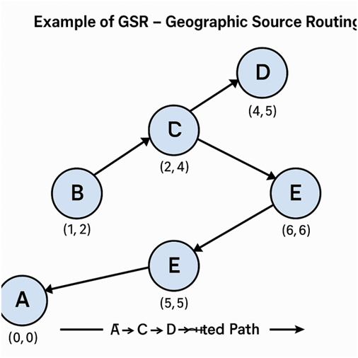
Let’s look at a basic scenario with a network of mobile nodes to better grasp Geographic Source Routing (GSR). Assume that a mobile ad hoc network consists of the following six nodes: Node A (Source), B, C, D, E, and F (Destination). Every node uses GPS to determine its own location and communicates this information to other nodes on a regular basis.
Network Layout (with Coordinates):
| Node | Location (X, Y) |
| A | (0, 0) |
| B | (1, 2) |
| C | (2, 4) |
| D | (4, 5) |
| E | (6, 6) |
| F | (8, 6) |
Step-by-Step Routing Example:
- Location Awareness:
- Each node broadcasts its current coordinates.
- Node A (source) knows the positions of B and C (its immediate neighbors).
- Graph Construction:
- Node A constructs a graph using neighbor tables and builds possible links based on connectivity and proximity:
- A → B
- B → C
- C → D
- D → E
- E → F (Destination)
- Node A constructs a graph using neighbor tables and builds possible links based on connectivity and proximity:
- Route Calculation:
- Node A applies a shortest path algorithm (based on geographic distance) to compute the full route to F.
- The optimal path is: A → B → C → D → E → F
- This path is then included in the packet header by Node A.
- Packet Forwarding:
- The packet travels hop-by-hop:
- A sends it to B.
- B checks the next hop (C) and forwards it.
- C sends it to D, and so on, until it reaches F.
- The packet travels hop-by-hop:
- Mobility Handling:
- If any node (say D) moves away or breaks the link, the source (A) is informed to recalculate the route, or a local recovery strategy may be applied if supported.
Outcome:
- The packet successfully reaches the destination using geographic data, avoiding the need for frequent route discovery.
- GSR ensures that the route is based on real-time physical proximity rather than logical or hop-count metrics.
This example shows how GSR minimizes delays and lowers control overhead by utilizing source-based routing and geographic coordinates to provide effective communication in a highly dynamic wireless network. If you would want a diagram that illustrates this path and the placement of the nodes, please let me know!
Consider a network with six nodes: A (source), B, C, D, E, and F (destination) to get a sense of how GSR functions in real-world scenarios. Because each node is mobile and GPS-enabled, it can determine its own location and communicate it to other nodes on a regular basis. The source, Node A, wishes to transmit a packet to Node F. Node A creates a local connection network by identifying its one-hop neighbors, such as Nodes B and C, using data from its neighbor database. Using a shortest path algorithm based on geographic distance, Node A analyzes this graph and concludes that the best route is A → B → C → D → E → F. The packet header then contains this complete route. Every node reads the next hop from the header as the packet is being delivered, and then sends it appropriately—B forwards to C, C forwards to D, and so on—until it reaches Node F. The packet travels effectively without the need for further route discovery or network-wide broadcasting because the path was precomputed using real-time position data. The source node (A) may be alerted if a node along the path (like D) goes out of range so that it can recalculate a new route and continue delivering. This illustration demonstrates how GSR uses source routing and geography data to facilitate quick, dependable, and loop-free communication in dynamic wireless situations.
Key Features of Geographic Source Routing
A reliable and effective routing protocol, Geographic Source Routing (GSR) was created to meet the demands of dynamic and infrastructure-less networks. Because of its primary characteristics, it is especially well-suited for mobility settings such as MANETs and vehicular networks. The key characteristics that set GSR apart are listed below:
- Location-Based Routing: GSR bases its routing decisions on the geographic coordinates of nodes. Through recurring beacon transmissions, each node is aware of both its own and its neighbors’ positions.
- Source Routing Mechanism: At the source node, the complete path from the source to the destination is computed and included in the packet. This makes routing behavior more manageable and predictable.
- Local Neighbor Table Maintenance: Every node keeps track of its one-hop neighbors’ most recent locations in a neighbor table. This aids in the creation of a local connection graph that supports routing choices.
- Effective Path Selection: GSR chooses nodes that move the packet closer to the destination by using geographic proximity to determine the path. The source employs a shortest path algorithm that takes into account actual distance rather than just hop count.
- Low Routing Overhead: GSR stays away from flooding and global route finding strategies that are typical of more conventional protocols like AODV or DSR. By depending on position updates instead of complete topology exchanges, it minimizes control messages.
- Scalability in Dynamic Networks: GSR scales effectively in big and mobile networks because it makes use of local location data. Even as the number of nodes or degree of mobility rises, it maintains its efficiency.
- Loop-Free Routing: Routing loops are avoided since the path is calculated at the source and rigorously adhered to.
- Beacon-Based Updates: Nodes update their neighbor databases with new location information by periodically beaconing. This prevents undue overhead and maintains the routing information up to date.
These key features make GSR an effective routing protocol for real-time, high-mobility environments such as:
- Vehicular networks (VANETs),
- Battlefield communications,
- Disaster response scenarios, and
- Sensor networks with mobile nodes.
In summary, GSR combines the benefits of source routing with the efficiency of geographic data, offering a practical solution for modern wireless network challenges.
Advantages and Disadvantages of Geographic Source Routing
Geographic Source Routing (GSR) brings several notable benefits to wireless and mobile networks, particularly in high-mobility environments. However, like any routing protocol, it also has some limitations. Understanding both sides helps evaluate its suitability for specific network scenarios.
Advantages of GSR
- Less Routing Overhead: By depending on geographic placements, GSR eliminates the need for regular route discovery and maintenance, which reduces control packet traffic.
- High Scalability: GSR can effectively scale to large networks with numerous nodes since it makes use of local information and source routing.
- Effective in High-Mobility Scenarios: It works well in dynamic settings with frequent and fast node movement, such as VANETs.
- Loop-Free Routing: This reduces the possibility of routing loops by precalculating the path and encoding it in the packet.
- Effective Route Calculation: Choosing a route based on geographic distance can result in quicker, more direct, and shorter routes.
- Fast Packet Delivery: Packets can be transmitted rapidly without requiring last-minute route selections because the path is known and predetermined.
Disadvantages of GSR
- Reliance on GPS or Location Services: Nodes often rely on GPS to determine their geographic coordinates, which may not be dependable or available indoors or in obscured locations.
- Beaconing Overhead: Especially in crowded networks, frequent location updates can use up power and bandwidth.
- Path Staleness: Delivery failures may result from the source-computed path becoming out of date during transmission due to node movement.
- Restricted in Sparse Networks: Because geographic forwarding relies on having reachable nodes in the direction of the destination, GSR may have trouble in sparse networks with low neighbor densities.
- Storage and Processing Load at Source: The computation of path computation and graph formation falls on the source node.
| Aspect | Advantage | Disadvantage |
| Routing Overhead | Low due to geographic routing | Beaconing may still consume resources |
| Mobility Handling | Works well in high mobility environments | Path may become invalid due to rapid node movement |
| GPS Dependence | Enables precise routing | Requires GPS or accurate location service |
| Scalability | Highly scalable with large numbers of nodes | — |
| Packet Delivery | Fast due to known route | May fail if route becomes stale |
In conclusion, GSR is highly effective in environments where nodes have access to accurate location information and where mobility is high. However, it may not be ideal in environments with low connectivity, GPS unavailability, or where dynamic path recalculation is critical.
Applications of Geographic Source Routing
Geographic Source Routing (GSR) is a powerful solution for routing in dynamic, infrastructure-less wireless networks where traditional routing protocols may fall short. By leveraging geographic position information, GSR provides an adaptive and efficient method of routing, especially suited to highly mobile or unpredictable environments. The following are key areas where GSR finds valuable application:
- Vehicular Ad Hoc Networks (VANETs): GSR is highly effective in vehicle-to-vehicle (V2V) and vehicle-to-infrastructure (V2I) communication scenarios. It efficiently handles the high mobility of vehicles, ensuring swift and reliable delivery of critical messages such as accident alerts and traffic updates. GSR also plays a crucial role in enabling intelligent transportation systems (ITS), where quick decision-making and real-time data exchange are vital.
- Military Tactical Networks: In battlefield environments where infrastructure is unavailable or unreliable, GSR supports communication among soldiers, vehicles, and command centers. It minimizes routing overhead and maintains stable communication links despite constant movement and changes in unit formations. Its scalability makes it suitable for large-scale, mobile tactical deployments.
- Disaster Recovery and Emergency Response: GSR is instrumental in coordinating communication in disaster-stricken areas where conventional networks are down. It enables location-aware operations among rescue teams and drones, ensuring reliable data exchange even in unpredictable environments. GSR’s infrastructure-free design allows for rapid deployment in emergencies, supporting effective search and rescue missions.
- Wireless Sensor Networks (WSNs) with Mobility: In applications like environmental monitoring, wildlife tracking, and mobile sensing, GSR helps transmit data efficiently across mobile sensor nodes. It reduces energy consumption by limiting the need for repeated route discoveries, making it a practical choice for resource-constrained and mobile WSNs.
- Smart City Infrastructure: GSR supports a wide array of real-time applications within smart cities, such as intelligent traffic control, smart parking, and emergency vehicle routing. It adapts effectively to dense and highly mobile environments, facilitating seamless communication between connected vehicles, devices, and infrastructure components.
- UAV (Unmanned Aerial Vehicle) Networks: For networks involving drones and aerial vehicles used in surveillance, logistics, or temporary communication setups, GSR enables reliable communication using GPS-based location information. It maintains network connectivity despite rapid changes in topology, making it ideal for UAV swarm operations and coordination.
GSR’s geographic awareness and infrastructure-independent design make it a robust routing protocol across diverse domains that demand scalability, mobility, and resilience in dynamic wireless environments.
| Application Area | Benefits of GSR |
| Vehicular Networks (VANETs) | Fast routing under high-speed movement |
| Military Networks | Scalable, infrastructure-free communication |
| Disaster Response | Reliable in disrupted or remote environments |
| Mobile Sensor Networks | Efficient energy-aware data transmission |
| Smart Cities | Location-based services and IoT integration |
| UAV Communication | Stable routing in airborne dynamic networks |
In GSR is ideal for real-time, mobile, and GPS-enabled applications where conventional protocols are either too slow or too resource-heavy.
Geographic Source Routing Comparison with Other Protocols
One of the numerous routing protocols created to address the difficulties of vehicular ad hoc networks (VANETs) and mobile ad hoc networks (MANETs) is Geographic Source Routing (GSR). It’s useful to contrast GSR with other well-known routing protocols in order to better comprehend its advantages and disadvantages. A comparison of a few popular protocols based on important performance factors may be found below.
GSR vs. DSR (Dynamic Source Routing)
| Aspect | GSR | DSR |
| Routing Type | Geographic, source routing | Reactive, source routing |
| Position Info | Requires GPS/location data | Does not use geographic information |
| Route Discovery | Uses local graphs and location tables | Uses route discovery via flooding |
| Overhead | Lower (uses beacons, no flooding) | Higher due to route discovery process |
| Mobility Support | Better (uses dynamic location updates) | Poorer in high mobility due to frequent route breaks |
| Suitability | Best for location-aware, high mobility scenarios | Suitable for small, less mobile networks |
GSR vs. AODV (Ad hoc On-Demand Distance Vector)
| Aspect | GSR | AODV |
| Routing Type | Geographic, source-based | Reactive, table-driven |
| Position Info | Uses geographic location | Does not require geographic data |
| Route Maintenance | Beacon-based updates | Uses sequence numbers and periodic hello messages |
| Scalability | High (location-based decisions scale well) | Moderate, suffers in large networks |
| Route Discovery | Proactive at the source using known locations | On-demand via network-wide broadcasting |
GSR vs. GPSR (Greedy Perimeter Stateless Routing)
| Aspect | GSR | GPSR |
| Routing Type | Source routing with full path embedded | Greedy forwarding with perimeter recovery |
| Loop Prevention | Loop-free by design (route is precomputed) | May require perimeter mode to avoid loops |
| Performance in Sparse Networks | Better (precomputed paths avoid dead ends) | May fail if no neighbor is closer to the destination |
| Overhead | Higher (entire path included in packet header) | Lower (stateless, header contains only destination info) |
| Flexibility | Good for structured environments like VANETs | Works well in dense networks with frequent topology changes |
Comparison Summary Table
| Protocol | Uses Location? | Routing Type | Best For | Routing Overhead | Mobility Support |
| GSR | Yes | Geographic Source-Based | High mobility, GPS-enabled networks | Moderate | High |
| DSR | No | Reactive Source-Based | Small, less dynamic networks | High | Low |
| AODV | No | Reactive Table-Based | General-purpose ad hoc networks | Moderate | Medium |
| GPSR | Yes | Greedy Forwarding | Dense location-aware networks | Low | High |
GSR stands out in scenarios where:
- Nodes have access to reliable location data,
- Network topologies are frequently changing,
- Fast and efficient routing is required (e.g., VANETs, UAVs, emergency response).
While it has higher packet header overhead compared to GPSR and needs GPS data (unlike DSR or AODV), it offers a robust balance between accuracy, speed, and scalability. GSR is an excellent choice when geographic awareness and high mobility support are top priorities.
Conclusion
A robust and flexible routing technique designed for the dynamic nature of wireless ad hoc and vehicle networks is Geographic Source Routing (GSR). GSR reduces the overhead typically connected with conventional routing techniques and allows for effective path selection by utilizing the actual locations of nodes. Because of its source-based routing and geographic awareness, it is especially well-suited for high-mobility settings with frequent, fast topology changes. We have examined GSR’s operation, salient characteristics, practical uses, and comparisons with other well-known routing protocols throughout this blog. The benefits it provides, like lower control overhead, loop-free routing, and high scalability, make it an appealing option for many real-time, mission-critical communication systems, even if it does require access to precise location data (usually via GPS). In conclusion, GSR is a clever, location-based method of routing that fits in nicely with contemporary requirements, particularly in situations where scalability, reactivity, and mobility are critical. Protocols like GSR will become more and more important in guaranteeing dependable and effective data delivery as wireless communication networks continue to expand in size and complexity.
Frequently Asked Questions (FAQs)
What is the main idea behind Geographic Source Routing (GSR)?
GSR is a routing technology that determines routing paths based on the geographic locations of nodes. Data can go via mobile wireless networks more effectively because it computes the entire path at the source and incorporates it into the packet.
How does GSR differ from traditional routing protocols like AODV or DSR?
In contrast to AODV or DSR, which depend on logical hop-based metrics and on-demand route discovery, GSR guides routing using physical coordinates (like GPS data), which lowers overhead and improves performance in highly mobile networks.
Does GSR require GPS for all nodes in the network?
Indeed, the ability of nodes to obtain precise location data—usually from GPS or other positioning systems—is essential to GSR. Geographically optimized routes cannot be calculated or followed by the protocol without this.
What happens if a node on the precomputed route moves away or goes offline?
Depending on the implementation and network architecture, the protocol may either initiate a local recovery mechanism or alert the source node to recalculate the path if an intermediate node in the route becomes inaccessible.
In which scenarios is GSR most effective?
GSR is perfect for any mobile network with GPS access and frequent topology changes, including vehicular ad hoc networks (VANETs), military or emergency response systems, and UAV networks.